
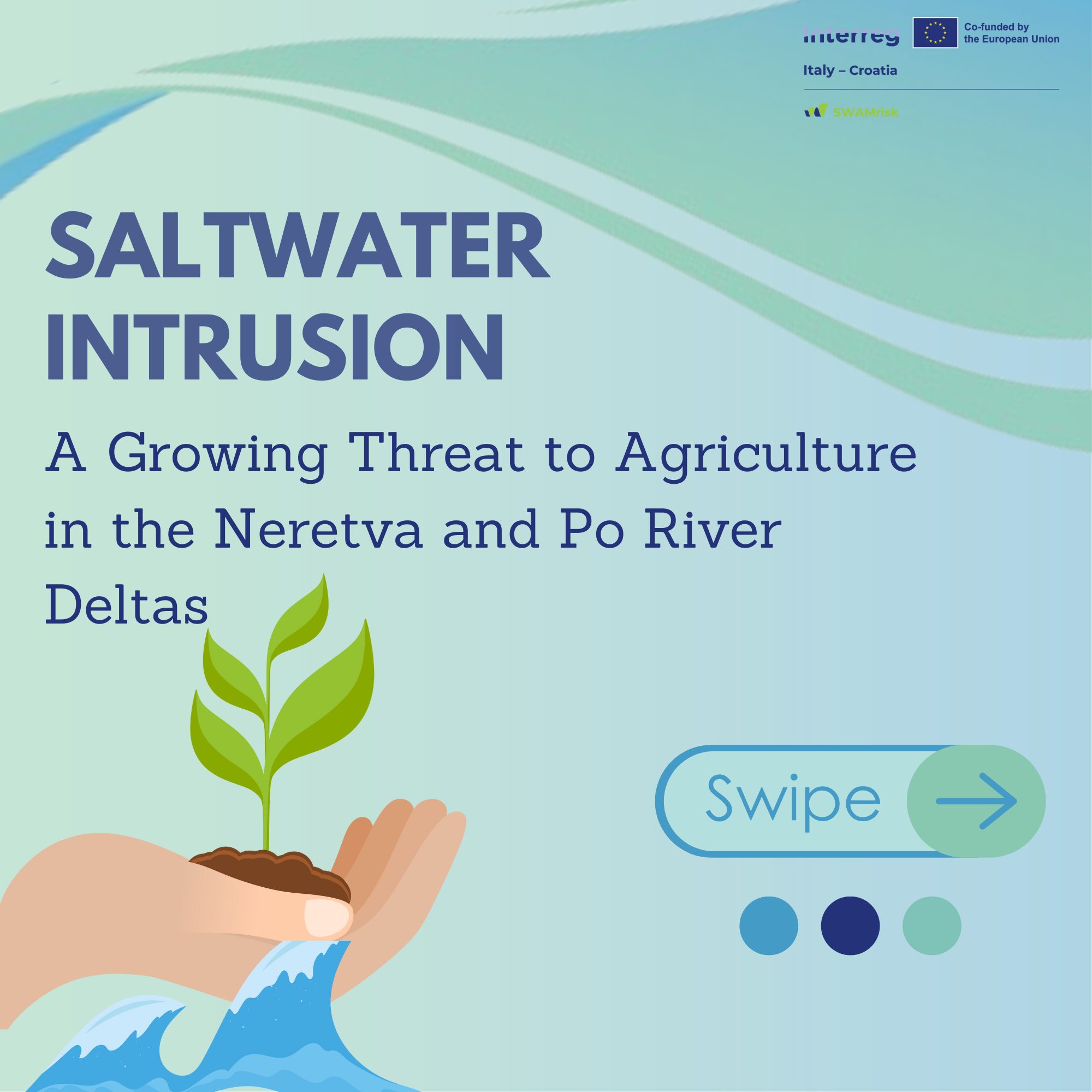
The Importance of Understanding Saltwater Intrusion
The SWAMrisk Project, co-funded by the Interreg Italy-Croatia Programme, focuses on studying and reducing the risks of saltwater intrusion in the Neretva and Po River Deltas.
Many of those who are most affected, such as agricultural companies, might not fully understand the real scope of the issue. It’s crucial to simplify complex scientific topics so everyone can better understand the impact and find solutions.
What is Saltwater Intrusion?
Saltwater intrusion happens when seawater moves into freshwater areas, contaminating rivers, groundwater, and agricultural land. This is especially dangerous in low-lying delta regions where sea level rise, droughts, and changes in river flow can make the problem worse.
Once saltwater reaches agricultural soils or freshwater resources, it can harm crops, reduce drinking water quality, and damage ecosystems.
Why is this a problem in the Neretva and Po Deltas?
Both the Neretva Delta in Croatia and the Po Delta in Italy are vital agricultural and ecological areas.
These deltas depend on a delicate balance between river freshwater and the nearby Adriatic Sea. However, several factors are increasing the risk of saltwater intrusion:
-
Rising sea levels linked to climate change push seawater further inland.
-
Reduced river flows, often due to upstream water use or prolonged droughts, make it easier for seawater to enter river channels and groundwater.
-
Land subsidence (the slow sinking of land) in delta regions lowers ground levels, worsening the risk.
Neretva Delta (Croatia):
The Neretva Delta is one of Croatia’s most important agricultural regions, known for fruit, vegetables, and vineyards. Farmers here rely on freshwater for irrigation, but in recent years, saltwater has been creeping into irrigation canals and wells — damaging crops and threatening livelihoods.
Pilot actions in this area focus on monitoring saltwater movement and testing new management solutions to protect farmland.
Po Delta (Italy):
The Po Delta is the largest wetland area in Italy and an important site for both farming and biodiversity. Here too, saltwater intrusion is becoming a serious issue, especially during dry periods when river flow is too weak to resist seawater.
Pilot sites in the Po Delta are testing innovative water management techniques and protective infrastructure to reduce saltwater intrusion and safeguard the environment.
Why does this matter to all of us?
Understanding saltwater intrusion is essential not only for scientists and engineers, but also for farmers, water managers, and local communities.
By learning how this phenomenon works — and how we can adapt to it — we can help protect local food production, drinking water supplies, and precious natural habitats.
The SWAMrisk project aims to make knowledge and practical solutions available to everyone, helping to build a more resilient future for our coastal regions.
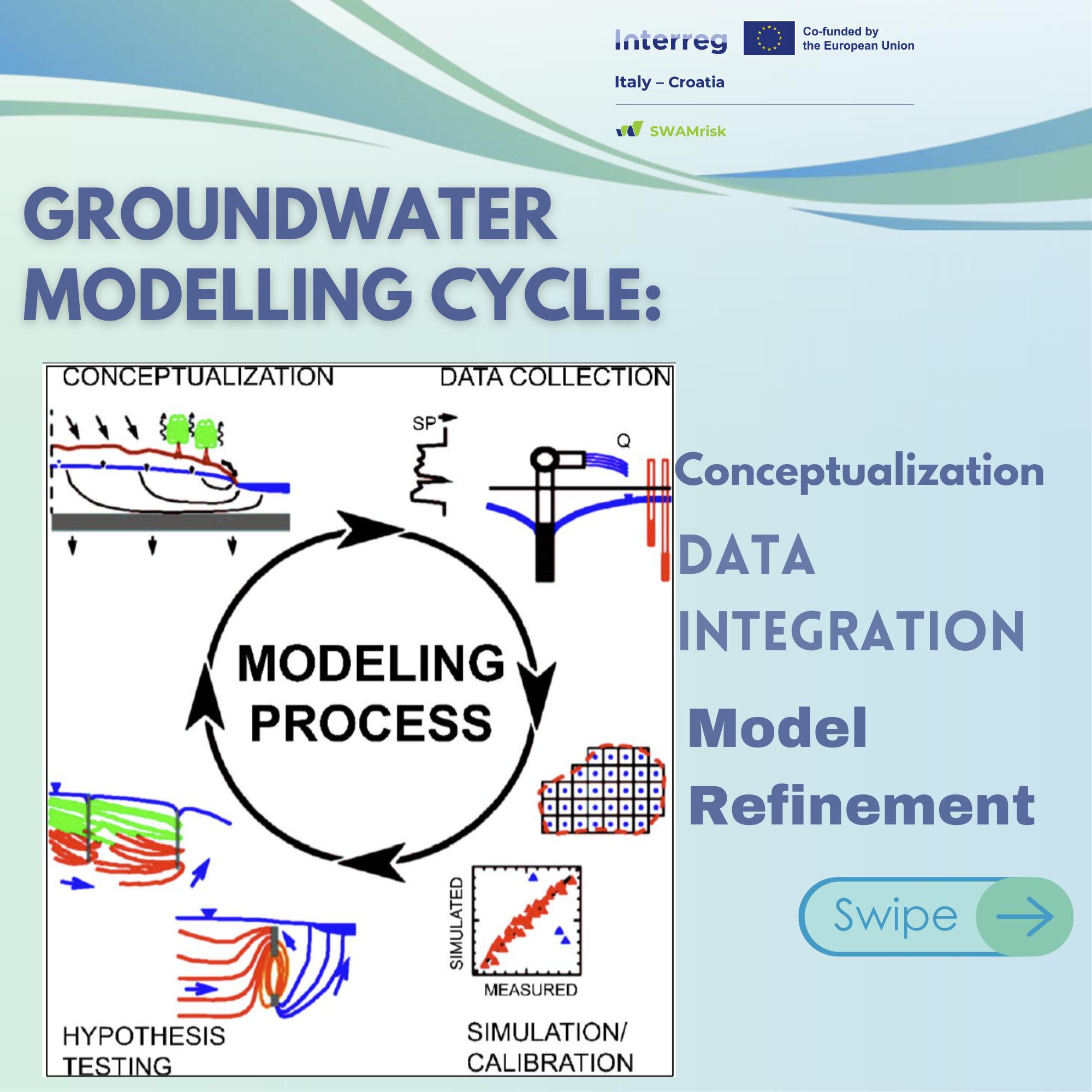
Saltwater Intrusion: Modeling in Action
This section provides an overview of the modeling process used in the SWAMRISK project to simulate saltwater intrusion and groundwater dynamics in vulnerable coastal agricultural areas.
🧠 Conceptual Model
The process starts with a conceptual model that defines subsurface geometry, boundaries, and hydrogeological properties based on field and geophysical data. This framework is then translated into a mathematical model to predict groundwater dynamics. A key challenge is that end-users often struggle to understand the model’s assumptions and limitations if not directly involved in its development.
🧮 Mathematical Model
The model uses a density-dependent flow and transport simulator to represent groundwater movement and solute transport. It accounts for variable fluid density, solute reactions, heterogeneity, time-dependent boundaries, and dispersive processes.
💻 Numerical Model
Simulations are carried out with the USGS open-source suite (ModelMuse, FloPy, and MODFLOW 6), chosen for its robustness, flexibility, extensive documentation, and long-term support.
📊 Communication
Clear summaries of assumptions, limitations, and results are essential to ensure transparency and build trust with stakeholders.
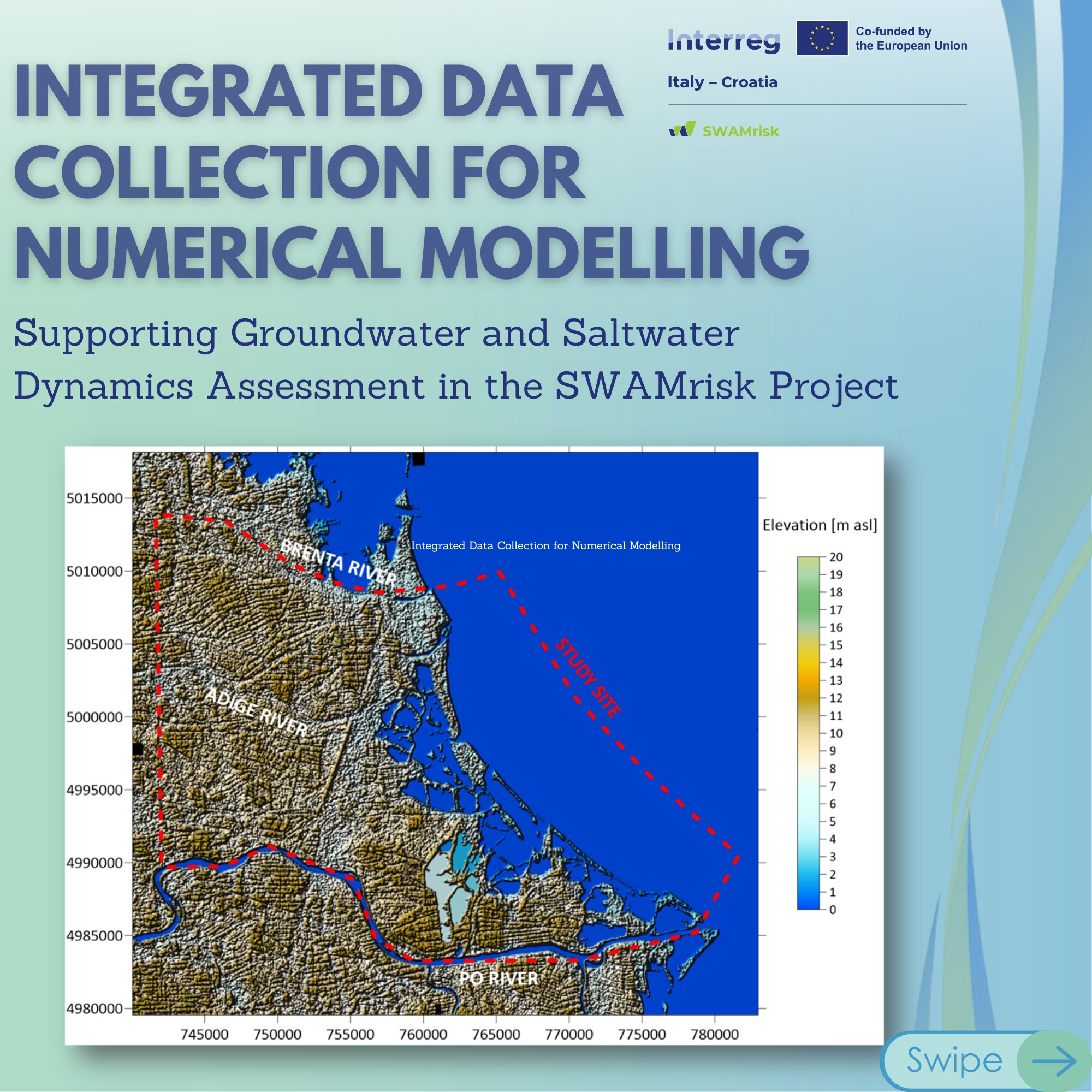
Integrated Data Collection for Numerical Modelling
As part of the SWAMrisk project, a comprehensive data collection process is underway to support the assessment and protection of coastal groundwater resources.
We're gathering information from:
-
 Scientific studies & technical report
 -
 Previous fieldwork & surveys
 -
 National & regional monitoring programs
What kind of data?
![]() Topography & Maps:
Topography & Maps:
- Using Digital Elevation Models (DEM) to define surface and boundaries
![]() Hydrogeological Data:
Hydrogeological Data:
- Lithostratigraphy – mapping underground layers
- Hydraulic conductivity – how easily water flows through different soils
- Piezometric heads – tracking groundwater levels
![]() Nature’s Input - Meteorological & Hydrological
Nature’s Input - Meteorological & Hydrological
- Rainfall & evapotranspiration
- River flows, seawater levels, saltwater
![]() Anthropogenic Influences
Anthropogenic Influences
- Groundwater pumping (for farms & industry)
- Drainage from land reclamation
![]() This vital data is the backbone of our hydrogeological modelling. It helps us simulate future scenarios and manage saltwater risks more effectively.
This vital data is the backbone of our hydrogeological modelling. It helps us simulate future scenarios and manage saltwater risks more effectively.
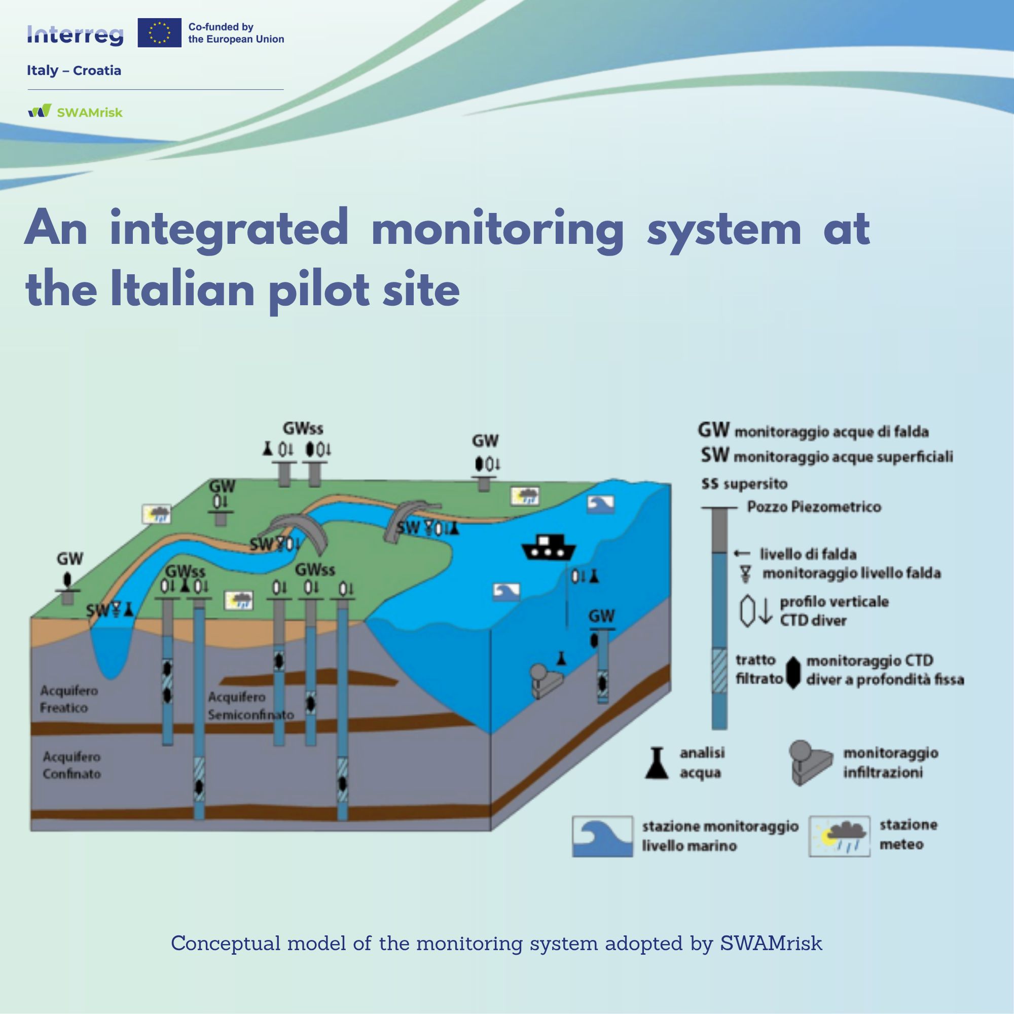
Why salt creeps into the Po River Delta and how SWAMrisk tracks it?
During droughts and low river flow, a saline wedge pushes inland through river branches and drainage canals. The result? Saltier irrigation water, soil salinization, and stress on freshwater habitats.
How SWAMrisk tackles it?
We’ve built an integrated monitoring system that ties together:
![]() continuous measurements of groundwater & surface-water levels
continuous measurements of groundwater & surface-water levels
![]() electrical conductivity (salinity) and temperature
electrical conductivity (salinity) and temperature
![]() data from existing networks, topped up with new stations in data-poor zones
data from existing networks, topped up with new stations in data-poor zones
![]() meteo and tide-gauge data from online databases
meteo and tide-gauge data from online databases
Before installing, the team updated databases, ran field inspections, and selected the best locations. We also identified critical zones and added stations to close information gaps.
![]() Together, this provides a strong basis for conceptualizing and modelling coastal hydrogeological dynamics—key to smarter water management in the Delta.
Together, this provides a strong basis for conceptualizing and modelling coastal hydrogeological dynamics—key to smarter water management in the Delta.
Why it matters? Better data → better decisions → protected soils, farms, and ecosystems.