
Diving into the Future: BRIGANTINE and the revolution of underwater habitat monitoring
12/12/2025
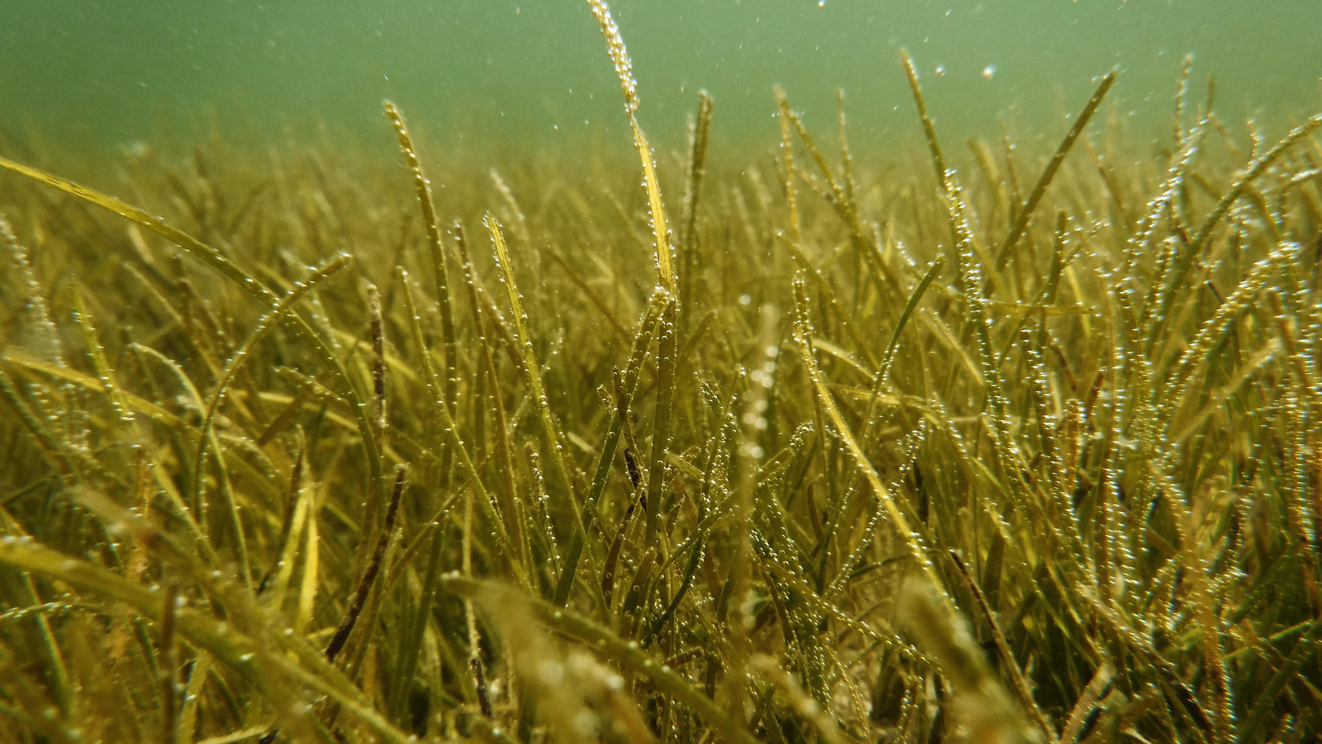
The sea hides forests we rarely see. Silent meadows of seagrass and algae that breathe life into our planet. These submerged ecosystems are biodiversity hotspots, oxygen factories, and natural carbon sinks. Yet they remain among the least monitored and most threatened environments on Earth.
The sea’s submerged forests are vanishing silently, but technology gives us a chance to listen before it’s too late. BRIGANTINE embodies the convergence of innovation, ecology, and urgency. By utilising a marine drone equipped with cameras and sensors, the project sheds light on the hidden dynamics of seagrass meadows and macroalgal beds, offering the tools needed to protect, restore, and sustain these fragile ecosystems for generations to come.
BRIGANTINE’s drone is a sentinel, a watchful eye beneath the waves, reminding us that what lies unseen is often what matters most.
A new era in marine monitoring
BRIGANTINE — short for Chemico-Physical and Multispectral Data Fusion for Adriatic Sea Monitoring by autonomous vessel — is a project born out of necessity. In the Adriatic Sea, where vast seagrass beds and algal meadows support rich ecosystems, traditional monitoring techniques have struggled to keep pace with the rapid environmental change.
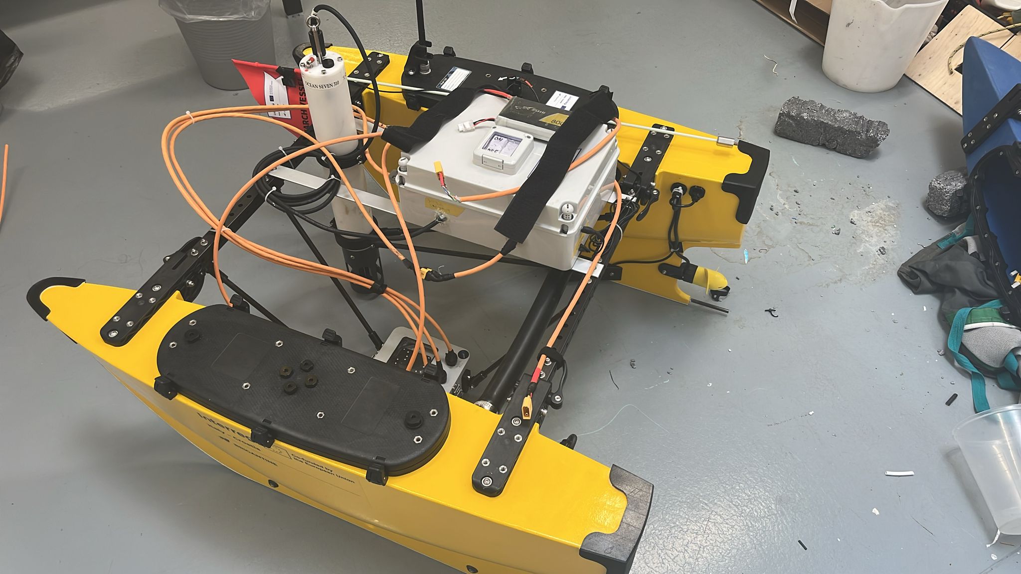
Scientists have long relied on scuba divers, stationary sensors, and sporadic satellite data to study these habitats. But such methods are labour-intensive, spatially limited, and unable to deliver continuous, real-time data. BRIGANTINE changes this paradigm by using a fully Autonomous Surface Vessel (ASV) equipped with an array of advanced imaging and sensing technologies.
The core technology
At the heart of BRIGANTINE is a marine drone specifically designed to operate in nearshore and coastal environments. Its lightweight frame and hydrodynamic design allow for efficient navigation even in shallow and complex waters.
The drone’s capabilities rely on three main technological pillars:
1. Visual Imaging Systems
High-resolution photo/video cameras mounted on the hull capture detailed images of seagrass meadows and macroalgal structures. These provide scientists with georeferenced visual datasets, enabling precise mapping of benthic habitats and an easy way to gain insights into the evolution of their distribution and seafloor coverage over time.
2. Environmental Sensor Suite
The drone integrates multi-parameter probes to measure chemical and physical properties of seawater, including:
- Temperature – critical for detecting thermal stress in seagrass meadows.
- Salinity – influencing species distribution and habitat stability.
- Dissolved Oxygen (DO) – essential for marine life.
- pH – indicators of ocean acidification.
- Pressure – it allows the calculation of the depth of a water body.
- Conductivity – it enables the study of water properties.
3. Pollutant Detection
BRIGANTINE can host sensors for measuring the presence of some pollutants, including heavy metals. These metrics are crucial for evaluating human-induced pressures on marine biodiversity.
Real-time visual monitoring
Unlike traditional surveys that require days or weeks for data processing, BRIGANTINE delivers real-time data transmission. Through integrated telemetry systems, researchers can track the drone’s position and observe its visual feed live from control stations.
This approach enables:
- Immediate habitat assessment in response to environmental events (e.g., algal blooms, heatwaves).
- Faster data integration into ecological models for resource management.
- Adaptive mission planning based on real-time sensor readings.
The ability to make on-the-fly decisions is crucial in marine conservation, where changing conditions can make static monitoring obsolete.
The hidden value of seagrass meadows
Seagrass meadows and macroalgal beds, often called the "submerged forests", are ecological powerhouses. Their importance spans multiple dimensions:
- Biodiversity Reservoirs: They provide habitat, nursery grounds, and feeding areas for countless marine species, from invertebrates to fish and even sea turtles.
- Carbon Sequestration: Known as "blue carbon" ecosystems, seagrass meadows absorb carbon dioxide up to 35 times faster than tropical rainforests.
- Coastal Protection: Their root and stem systems stabilise sediments, reducing erosion and buffering storm surges.
- Water Quality Enhancement: By trapping nutrients and particulates, they naturally filter seawater.
Yet, these ecosystems are under siege. Coastal development, pollution, and rising sea temperatures pose a significant threat to their survival. According to recent studies, global seagrass cover is shrinking by approximately 7% per year. Without intervention, many habitats could reach a tipping point of irreversible decline.
How BRIGANTINE advances science
The BRIGANTINE project combines autonomous technology with ecological modelling to offer scientists unprecedented tools for ecosystem management:
- High-Resolution Mapping: By combining visual imagery with bathymetric (depth) data, BRIGANTINE generates precise distribution maps of submerged vegetation.
- Data Integration into Predictive Models: The collected datasets feed into computational frameworks that simulate habitat resilience under different climate and pollution scenarios.
- Early Warning Systems: By continuously tracking environmental stressors, BRIGANTINE enables authorities to implement proactive conservation measures.
Such advancements are expected to dramatically improve the cost-effectiveness and spatial coverage of marine monitoring programs in the Adriatic Sea and beyond.
Challenges and innovations
Developing a marine drone capable of autonomous underwater habitat monitoring presents several challenges. Some key challenges include:
1. Navigation in Complex Environments
Coastal ecosystems are dynamic, with variable currents, shallow zones, and obstacles like reefs. BRIGANTINE’s navigation system is based on GNSS (Global Navigation Satellite System), via GPS (Global Positioning System), for precise positioning, even under challenging conditions.
2. Energy Efficiency
The drone utilises a hybrid power system combining rechargeable lithium-ion batteries. This extends operational autonomy, allowing BRIGANTINE to conduct multi-day surveys without human intervention.
3. Environmental Non-Intrusiveness
A key design principle was to minimise disturbance to sensitive habitats. Low-noise propulsion systems and optimised hull shapes reduce the risk of impacting wildlife.
From data to policy
The ultimate goal of BRIGANTINE is not just to collect data, but to translate science into action. By creating a centralised data hub, the project facilitates:
- Sharing datasets among researchers, conservationists, and policymakers.
- Supporting local authorities in designing Marine Protected Areas (MPAs).
- Enabling evidence-based decision-making for sustainable coastal management.
This integrative approach fosters collaboration across disciplines, linking marine ecology, robotics, data science, and environmental policy.
BRIGANTINE explicitly aims to engage with the Quadruple Helix of Innovation framework, comprising universities, industry, government, and the public, fostering a participatory and cross-sectoral approach to marine conservation. This ensures that knowledge transfer and technological innovation are not confined to academia, but also benefit small and medium-sized enterprises (SMEs), which play a critical role in developing and scaling new solutions for the blue economy.
A model for the future
While BRIGANTINE is currently focused on the Adriatic Sea, its methodology has global implications. Similar marine drone systems could be deployed in other sensitive regions, such as:
- Coral reef ecosystems threatened by bleaching events.
- Arctic kelp forests impacted by rising temperatures.
- Estuarine zones suffering from nutrient overload and hypoxia.
By scaling this technology, scientists envision a network of autonomous monitoring platforms feeding continuous environmental data into international marine databases. Such a network would mark a leap forward in planetary stewardship.