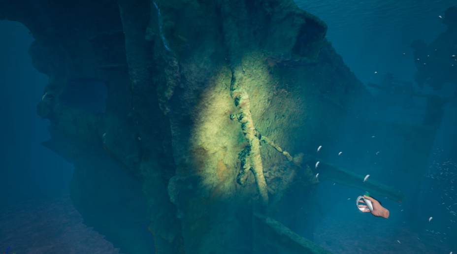
These activities are fully coherent with the objectives of Work Package 4.1 of Adrireef project “Monitoring of Adriatic reefs in Italy”, where innovative monitoring technologies able to support the blue growth need to be proposed and tested. “Paguro” is the name of an Agip jack-up platform sunk in 1965 following an accidental uncontrolled gas emission that occurred during drilling operations. The site, located 12 nautical miles offshore Ravenna (Adriatic Sea), is an artificial reef where some other decommissioned assets were added in the past. The structural complexity of the artificial reef provides hard substrates for benthic organisms, refugees and hunting areas for pelagic fishes.
The Paguro is the result of a naturalization process that lasted for about 55 years and, thanks to its biodiversity and richness, it’s protected by National and European regulations. Scuba diving and scientific research are the only allowed activities at site. To support ARPAE Emilia-Romagna, Ubica srl designed a set of tools for studying the Paguro integrating traditional sampling methods with innovative photogrammetric based 3D reconstructions.

The underwater 3D scanning of the wreck was carried out at 2 different resolutions to cover different extents. The high resolution mapping was performed over small areas (approx 5 square meters) to produce detailed 3D representation of the site. From these models it was possible to calculate the volume of the ongrowing organisms. This information was then associated with the results achieved during taxonomic analysis and estimations of benthic biomass. The results showed how the composition of the different benthic communities changed across the wreck and how much its growth contributed to the naturalization process at different depths.
The 3D scans generated large point clouds with a minimal distance between points of one micron. The high resolution of these models allowed the fine computation of the three-dimensional complexity of the microhabitats composed by mussels, sponges, bryozoans, brittle stars, soft corals and hydroids.

To calculate the thickness of the overgrowing fouling, primitive geometries were generated and sized to fit the models. For example steel members of the platform dimensioned 35 and 55 centimeters in diameter were reconstructed and fitted to the 3D scans.

The low resolution 3D scans were carried out over large portions of the wreck for creating a 3D view of the site and 3D maps of the benthic communities according to their composition.

The photographic datasets were used to identify two main communities and two specific representative facies on the scanned sections of the wreck. The infralittoral communities are well represented by red algaes and the large abundance of mussels which domain the facies of Mytilus galloprovincialis.

The twilight community has no photosynthetic species. Suspension feeders, filtrators and detritivores organisms well represent the benthic community where oysters take the place of mussels and, in the deeper areas, the detritivorous echinoderm Ophiothrix fragilis prevails.

Based on these observations, a 3D point cloud map of the wreck was created by segmenting and classifying it.
Finally, in collaboration with the project partner Municipality of Ravenna, the 3D models of the wreck were implemented with new data, optimised and processed within a 3D environment for creating virtual reality immersive experiences simulating a scuba diving and the underwater exploration of the Paguro wreck. The application for exploring the wreck will be delivered by March 2021.